Sacred Directions
Find Qibla (Mecca), Jerusalem, Vatican, or any sacred place with real-time precision.
Arrow to Pin is the free offline iPhone and iPad app that combines a precision GPS compass, a real-time Qibla finder, a live sun and moon position tracker, a complete moon phase calendar, and a smart location-sharing system for any coordinates on Earth. Online catalog of famous world landmarks. 14 languages. Privacy first.

The most accurate offline compass, Qibla finder, and astronomical tracker for iPhone
Getting lost in a foreign city, missing the Qibla while traveling, or arriving at the trailhead too late for sunset can ruin a trip. Arrow to Pin is a precision iPhone and iPad app designed to give you a single, reliable answer to "which direction?" and "which time?" no matter where you are. Whether you need the direction to Mecca for prayer, the bearing back to your parked car, the exact moment of sunrise for a photograph, or the lunar phase for a camping night, every reading is computed on-device with sub-degree precision and works fully offline.
Unlike generic compass apps, Arrow to Pin is built around destinations and astronomy. The app combines a GPS compass with bearing-to-target and distance, a real-time Qibla compass aimed at Al Kaaba, a complete sun tracker (sunrise, solar noon, sunset, civil/nautical/astronomical twilights, day length), a moon tracker with the 8 lunar phases, illumination, lunar day, distance, and azimuth/elevation, and a location-sharing system based on Apple Universal Links. It comes with an online catalog of famous world landmarks covering religious sites, tourist landmarks, sports venues, government buildings and geographic wonders. Every coordinate is verified against OpenStreetMap and Wikidata, every name is provided in the local script, and the app speaks 14 languages with full RTL Arabic support.
Your data stays private and works without internet: GPS readings are processed on-device by iOS Core Location, sun positions use the NOAA Solar Calculator (accuracy ±0.01°), moon positions use Jean Meeus astronomical algorithms verified against NASA JPL ephemerides (±27 minutes), and your saved points never leave your iPhone. The optional 4-digit App Lock, hashed locally with a per-device salt in the iOS Keychain, adds an extra layer of protection.
Precision compass, Qibla finder, sun and moon tracker, and an online catalog of famous world landmarks you can save in one tap.
Find Qibla (Mecca), Jerusalem, Vatican, or any sacred place with real-time precision.
Browse the online catalog of famous landmarks: mosques, cathedrals, temples, wonders, stadiums, mountains and more. One tap to save.
Watch the distance update in real-time as you move toward your destination.
Sector turns orange when close, green when aligned. A checkmark appears when you've arrived at your destination.
N, E, S, W letters inside a precise dial with dense graduations every 2° and degree numbers every 30°. Always know where North is - the red N and red '0' make it instantly visible.
Real-time margin of error for position, altitude, and speed - so you always know how reliable each reading is.
Your movement speed displayed in real-time (km/h or mph), calculated by GPS as you walk, cycle, or drive.
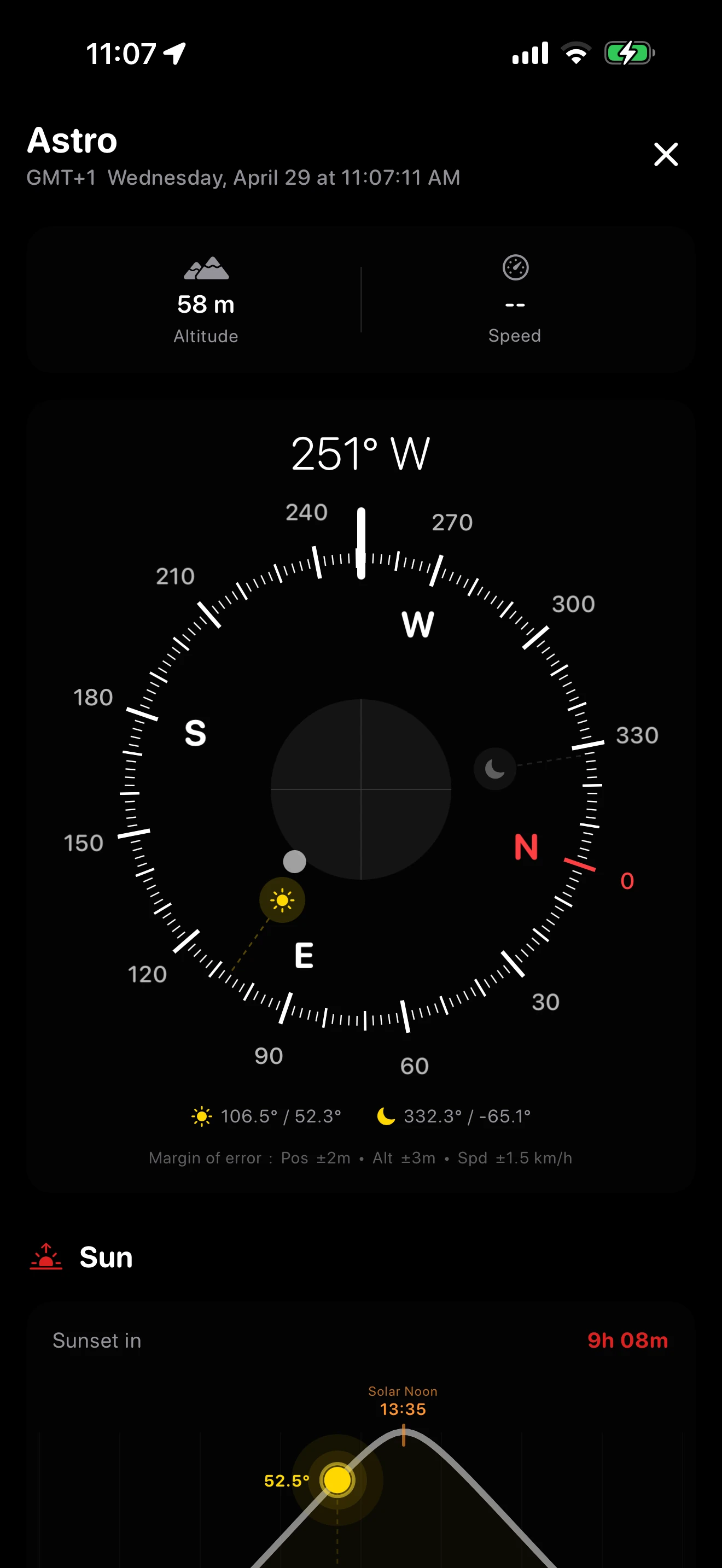
Real-time sun position on the compass dial. 24-hour solar arc showing sunrise, sunset, solar noon, and twilights. Powered by the NOAA algorithm (±1 minute accuracy).
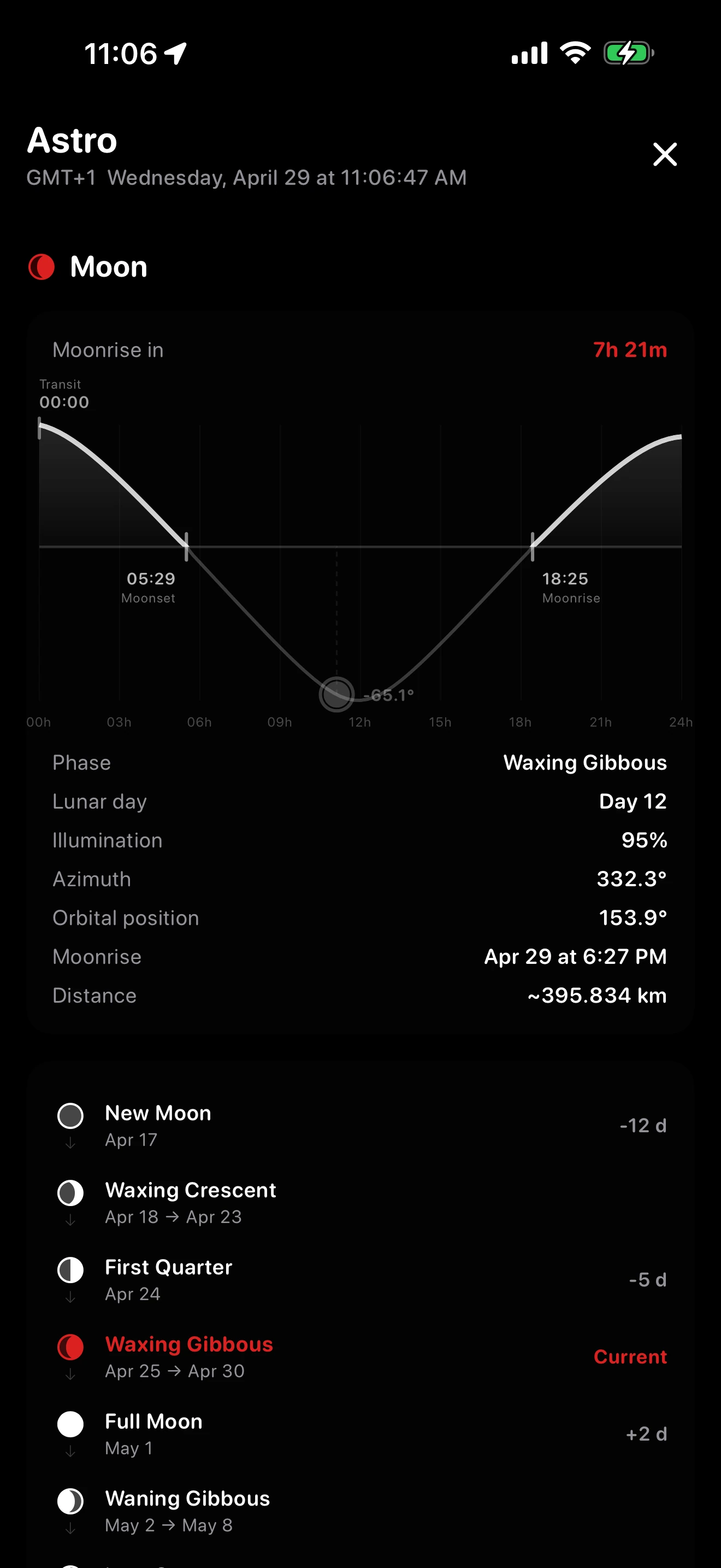
Lunar position, phases, illumination, distance, and moonrise/moonset times. 24-hour moon arc animation. All 8 phases with exact dates calculated by Jean Meeus' algorithm (verified against NASA JPL).
All 8 lunar phases with exact dates. Primary phases shown as precise moments, intermediate phases as date ranges. Verified against NASA JPL Horizons to ±27 minutes.
Solar and lunar trajectory charts spanning 24 hours. Sunrise, sunset, twilights, moonrise, moonset, and transit - all on elegant animated curves.
A dedicated compass on the Astro page showing the real-time position of both the sun and moon, with a built-in level indicator. Direction indicator changes color when pointing at celestial objects.
Send any saved point to friends as a smart link. WhatsApp, iMessage, Mail, anywhere. The recipient opens the app directly on the compass for that point, or sees a preview page if Arrow to Pin isn't installed yet.
Compass calculations work without internet connection.
Your saved points stay on your device, no cloud sync, no account required. The optional 4-digit App Lock keeps everything behind a PIN, hashed locally in the iOS Keychain.
Optional 4-digit PIN protects access at launch and after returning from background. Stored as a salted SHA-256 hash in the iOS Keychain, never synced, never readable. Forget the code? Reinstall the app.
English, French, Arabic, Spanish, German, Turkish, Portuguese, Italian, Indonesian, Dutch, Russian, Polish, Japanese, Korean. Full RTL support for Arabic. Pick your language from Settings, applied at next launch.
The screen stays awake while the compass or Astro page is open, so you never have to unlock your phone during navigation. Disable anytime in Settings.
14 ways Arrow to Pin helps you every day
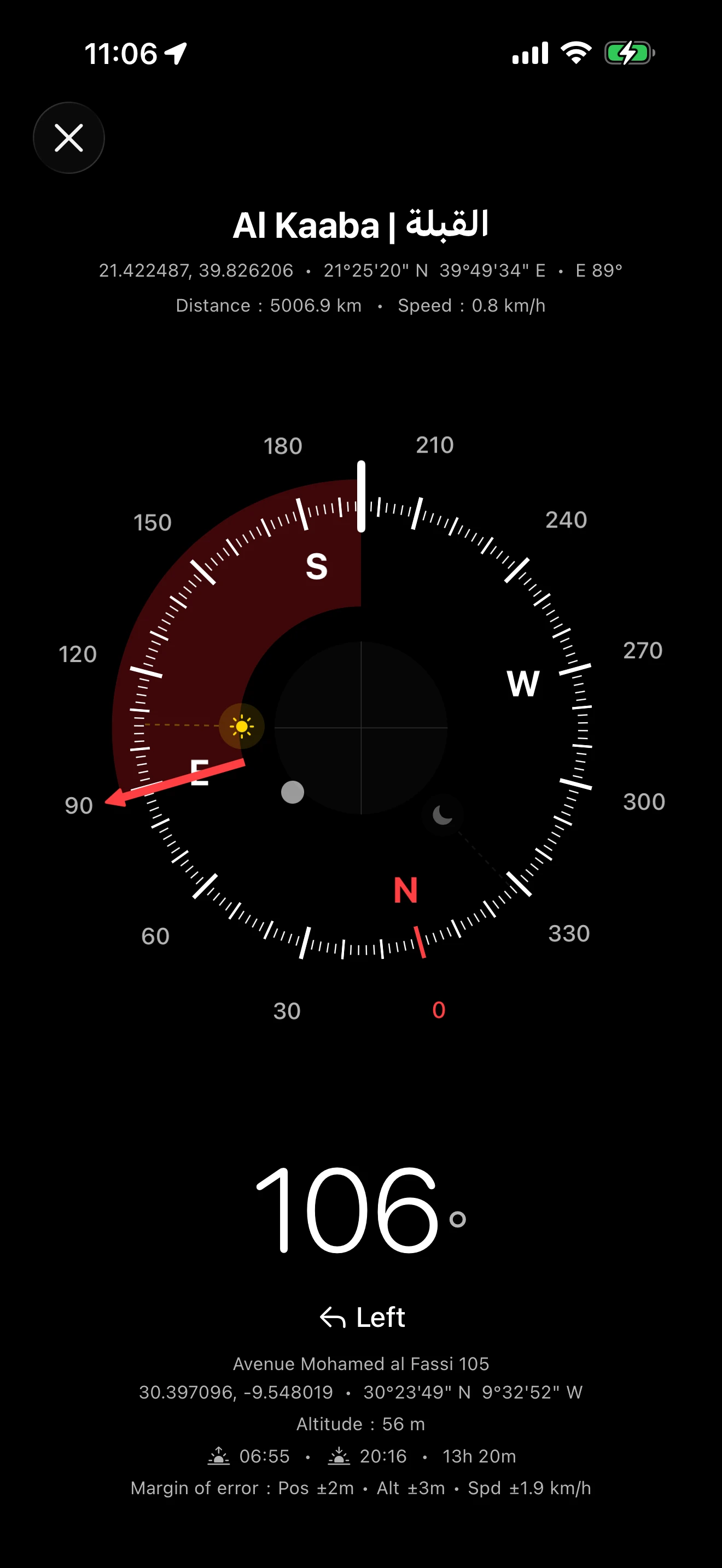
You're in a hotel room in Tokyo and need to pray. Open Arrow to Pin, select the Kaaba, and the compass points directly toward Mecca with real-time precision. No internet needed. The calculation is done offline from your GPS coordinates. Works anywhere on Earth, even in remote areas with no cell service.
During Hajj or Umrah in Mecca, millions of pilgrims fill the streets. Save your hotel's GPS coordinates before leaving. After Tawaf or Sa'i, open the app and follow the compass arrow back. The distance counts down in real time as you walk, and a green checkmark confirms when you've arrived. No need to read street signs or ask for directions.
You parked in a massive airport or shopping mall parking structure. Before leaving your car, save the spot using your current GPS location. When you return hours later, select that point. The compass shows the exact direction and distance. As you orient your phone toward the car, the sector turns orange when close to alignment, then green when fully aligned. Walk straight toward the arrow until the green checkmark confirms arrival.
Large cemeteries have thousands of graves with few visual landmarks. Save the GPS coordinates of a loved one's grave on your first visit. On subsequent visits, even months later, open the app and follow the arrow directly to the exact spot. The precision goes down to 11 cm with good GPS signal. No more wandering between rows.
You're at the base of a mountain and want to know exactly which direction the peak is. Select Mount Everest, Mont Blanc, or any of the 44 geographic landmarks. You can also add your own summit coordinates. The compass shows the bearing while the Astro page tells you where the sun will set behind the mountain for that perfect golden hour photograph.
You're hiking in a desert or dense forest with no trails, no signs, and no cell service. Save your starting point (campsite, trailhead, or vehicle). Explore freely knowing that the compass always points back. The app works 100% offline. All calculations are done on-device using GPS. The margin of error tells you how reliable your position is.
You're a photographer planning a landscape shoot. The Astro page shows you exactly when and where the sun will rise and set with ±1 minute accuracy. The 24-hour solar arc chart visualizes the entire trajectory. The sun marker on the compass dial shows the real-time azimuth. Point your phone and see exactly where the sun is or will be. Perfect for planning golden hour shots.
You need to know when the next full moon is for a night photography session, a camping trip, or religious observance (Ramadan, Jewish calendar). The app shows all 8 lunar phases with exact dates calculated by Jean Meeus' algorithm, verified against NASA JPL to ±27 minutes. The lunar day counter tells you exactly where you are in the 29.5-day cycle.
You're in a foreign country with no local SIM card and no Wi-Fi. Arrow to Pin works 100% offline. All compass calculations, sun/moon tracking, and astronomical algorithms run directly on your device using only GPS. The only feature that requires internet is the location name geocoding. Coordinates, direction, and distance work without any connection.
You're at a music festival, a stadium, or a large outdoor event with thousands of people. A friend saves their location and shares the GPS coordinates with you. Add the point and follow the compass through the crowd. The distance counts down meter by meter. No more "Where are you?" phone calls. The arrival alert vibrates when you're within range.
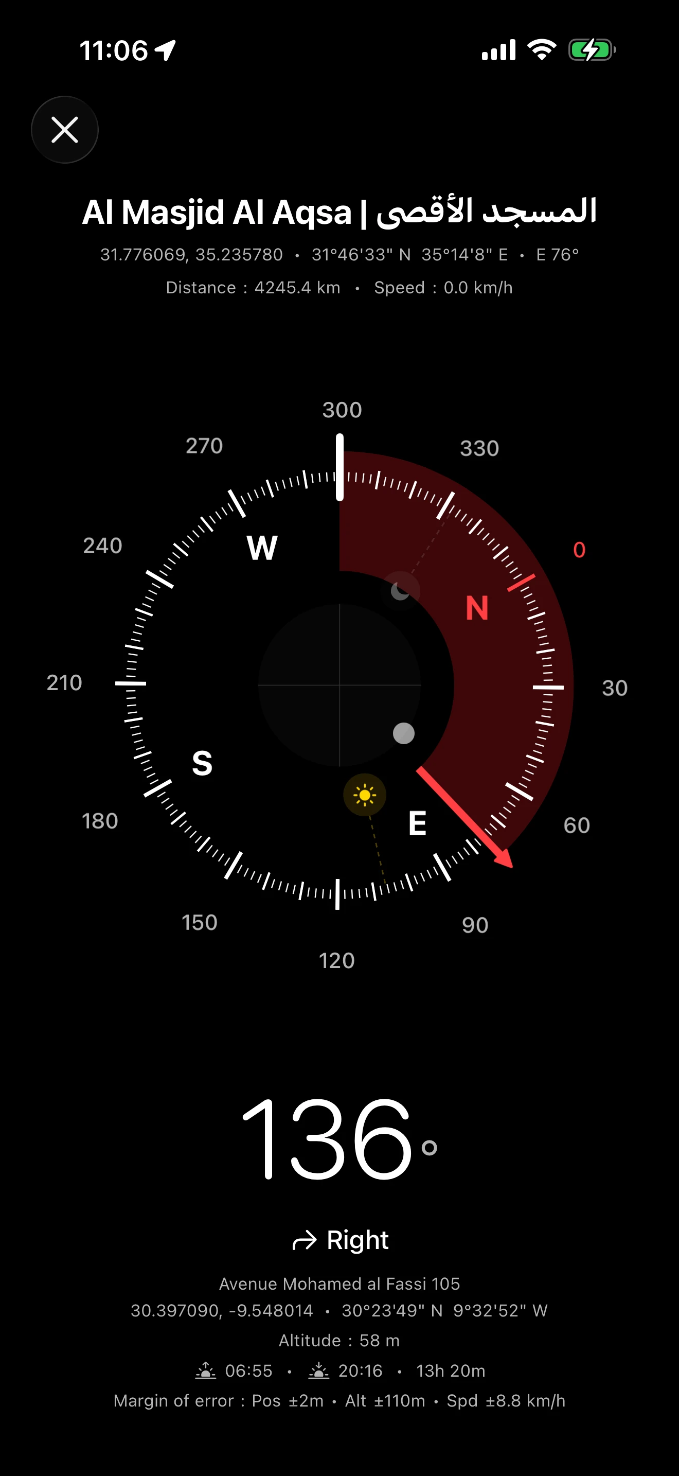
You're visiting Jerusalem, Rome, Varanasi, or Bodh Gaya. The online catalog includes 30 religious landmarks: mosques, churches, temples, synagogues, and shrines. Save the ones you need before your trip. Select a site and follow the compass to navigate on foot through unfamiliar streets. The alternative names in local scripts (Arabic, Hebrew, Hindi, Chinese, Japanese, Greek) help you match what you see on signs.
The Astro page shows exactly when twilight ends for complete darkness. Useful for stargazing or knowing when to set up camp before nightfall.
All FIFA 2026 World Cup stadiums are in the online catalog ready to save: MetLife, SoFi, AT&T, Hard Rock, NRG, Mercedes-Benz, Gillette, Levi's, Arrowhead, Estadio Azteca, Estadio BBVA, BC Place, BMO Field, and more. Navigate from your parking spot or hotel to the stadium entrance. After the match, the compass guides you back. Works in every host city across the US, Mexico, and Canada.
The solar arc chart shows the exact position of the sun throughout the day with sunrise, solar noon, and sunset times. The three twilight levels (civil at -6°, nautical at -12°, astronomical at -18°) help estimate prayer times for those who follow sun-based schedules. The Qibla compass combined with sunrise/sunset data gives you everything you need in one app: direction and timing.
Browse the online landmarks library and save any place to your Arrow to Pin app in one tap. Six categories spanning the planet's most meaningful coordinates.
Kaaba, Al-Aqsa Mosque, Vatican, Notre-Dame, Hassan II Mosque, Sagrada Família, Golden Temple, Bodh Gaya, Sheikh Zayed Mosque…
Compute the Qibla toward Mecca, plan a Hajj or Camino de Santiago pilgrimage, or simply find the nearest sacred site of any faith.
Eiffel Tower, Taj Mahal, Burj Khalifa, Colosseum, Pyramids of Giza, Statue of Liberty, Cristo Redentor, Petra, Machu Picchu…
UNESCO World Heritage sites, the New Seven Wonders, world-famous towers and museums. Pin them before your trip to navigate on foot.
All FIFA 2026 stadiums (MetLife, SoFi, Estadio Azteca, Wembley…), Camp Nou, Santiago Bernabéu, Maracanã, Old Trafford, NFL stadiums, Wimbledon, Roland-Garros, Circuit de Monaco…
Stadiums, arenas, racetracks and tennis courts that have hosted World Cups, Super Bowls, Olympic Games and Grand Slams.
White House, Kremlin, Buckingham Palace, Élysée, Reichstag, United Nations Headquarters, European Parliament, Forbidden City, Casa Rosada, Rashtrapati Bhavan…
Parliaments, presidential palaces and international institutions across every continent. The seats of global decision-making.
Mount Everest, K2, Kilimanjaro, Denali, Mont Blanc, Matterhorn, Mount Fuji, Aconcagua, the Seven Summits, Uluru, Dead Sea, Cape of Good Hope, Strokkur geyser…
Highest peaks, active volcanoes, iconic capes and unique natural features. From summit to sea level, every coordinate is verified.
Your parked car, hotel, campsite, a friend's house, a grave in a cemetery, a meeting point at a festival, your home, your favourite restaurant…
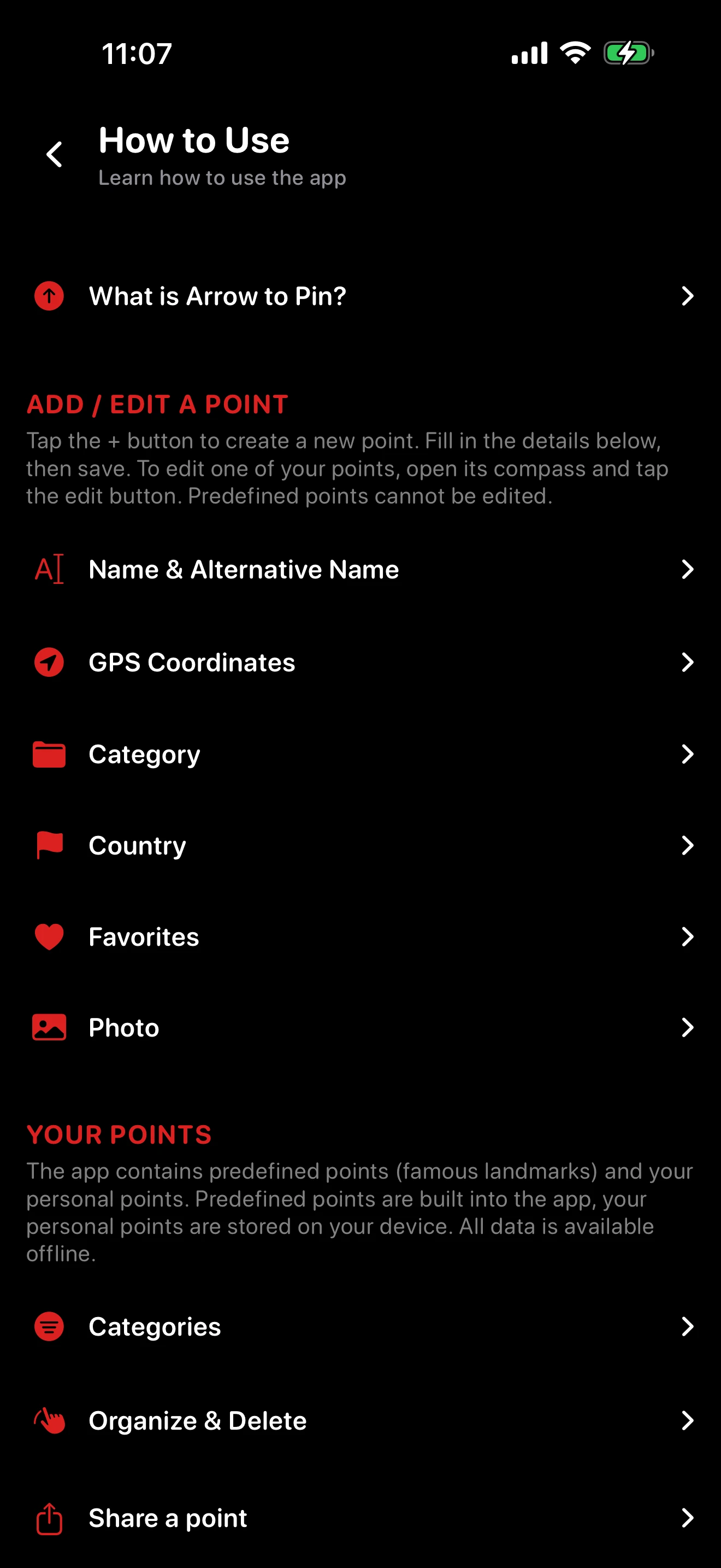
Tap the « + » button in the app to save any GPS coordinate as a personal point. Stays on your device, never synced, sub-meter precision.
The difference between a magnetic-only compass and a destination-aware navigator
Apple's stock Compass app is great for showing magnetic north and your current heading, but it stops there. It doesn't know where you want to go, it doesn't compute the great-circle bearing to a destination thousands of kilometers away, it doesn't track the sun and moon, and it doesn't pre-load any of the world's famous landmarks. Arrow to Pin is built around the question "in which direction is X right now?" where X can be Al Kaaba in Mecca, the Eiffel Tower, Mount Everest, your hotel, or your parked car.
For each saved point, Arrow to Pin gives you:
The iOS Compass tells you where you're facing. Arrow to Pin tells you where you need to go and when the sky will help you get there.
Everything you might want to know before downloading the precision compass
arrowtopin.com/share?n=…&lat=…&lng=…) that opens directly in the app for the recipient if installed, or shows a preview page with Apple Maps and Google Maps fallbacks if not. Works through WhatsApp, iMessage, Mail, AirDrop, Telegram, Signal, anywhere you can paste a link. Recipients can save the shared point to their own library in one tap.Download the free offline compass, Qibla finder, and sun & moon tracker for iOS. No account required. Privacy first. 14 languages.